


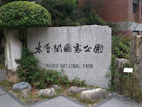
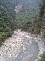
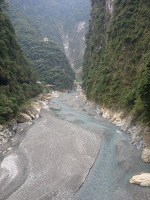
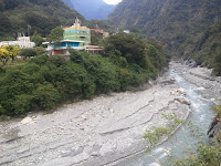
How do I describe Taroko Gorge? Well, it is one of those places that make you stop and stare, after which you begin to be grateful that you were born in this awesome planet. After the exhausting trip characterized by what seemed like endless walking and non-stop snapping of photos, I realized that the place is just full of rocks, huge rocks, which has sort of become the defining attribute of the place. What seems to be a river has become a narrow stream of water, that is apparently the result of the dam controlling the water’s flow.
I was supposed to follow the guide provided by the Taroko tour map I got from the visitor’s information office. According to that map, I should have started at 9 AM and ended at 6 PM. I woke up early at around 7:30 AM to prepare, but laziness got the best of me once again, and so I got up around an hour later and decided I would just take the 10:30 AM bus. Besides, what difference would an hour and a half make when some of the attractions are actually closed. I found out that an hour and a half makes a lot of difference, especially when you are so good in making bad decisions on which paths to follow, and when to ride the bus.
TWD 250 is the cost of an unlimited day pass for the Taroko tour bus. The catch is that they only come every hour, which means you'll have to walk to some of the destinations if you're in a hurry or if you finish one earlier than expected. Good preparation is ideal if you plan to maximize this unlimited bus deal. If you don't want an unlimited pass, you can still use the bus and pay the fares computed by distance, which are also provided there on the map.
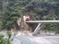
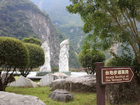
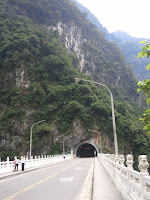
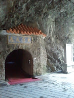
The first bad decision was to skip the Taroko Archway in favor of the Visitor Information Center. The timetable says that the two are just five minutes away from each other by bus. On foot, maybe triple that and you have 15 minutes, which isn't so far. I never saw the archway again until we got home, and only while I was on the bus. I was supposed to backtrack from the Visitor Information Center to the archway but I ended up going straight to Shakadang Bridge via a tunnel because I kind of lost my sense of direction. Anyway, the archway is just an archway, and the magnificent view of the river/stream below is duplicated and even outdone by many similar formations en route to Tianxiang.
Shakadang Trail was closed because of rockfall that left some paths blocked. You can still hang out on the bridge and take pictures. It's a pity because they say that this is one of the more popular spots here along with the Tunnel of Nine Turns, which was also closed for the same reason. Nonetheless I still had a good, albeit exhausting, time exploring this natural park because its beauty is evident everywhere you go. As I would love to say, Lord of the Rings-ish.


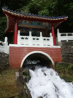
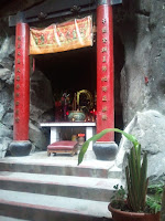
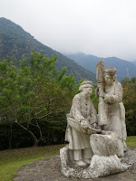
The next bridge leads you to a temple on top of a hill. The climb is not that long but exhausting anyway. There is a hanging bridge which would have been interesting to cross had it not been closed for the same reason as the others. You can still cross the short tunnel after that and end up in what seems to be the most photographed area of Hualien: that temple thingy with a mini waterfall under it. Once you get past the short tunnel, there will be an entryway to the left which leads you to a viewing deck, a Buddha altar, and a tunnel by the cliff that leads to the temple itself which turned out to be a gazebo, a worshiping area, and a bridge. I don't know if they are actually used as worshiping places. It seemed to be just a plain tourist spot.

What followed had to be the longest walk I have had in weeks, or even months. You see, I should have just followed the itinerary on the guide. Besides, they know the place better than I do, right? Oh well, stubbornness rules but in fairness to myself at least I've a had a really good exercise for my legs which they badly needed, as in. One thing I'd recommend is to avoid this. AVOID walking to and from the Eternal Spring Shrine/Shakadang to Buluowan and vice-versa. You are in for one heck of a long hike and the time you spend doing so can be used for exploring some other sites, unless you really need the exercise. Excuses!
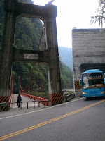

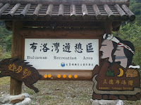
And so how and where did I end up? I ended up at Buluowan, but not after a few hours of walking. I was counting kilometers like crazy because at least there were markers all over the road. Every time I got to finish a hundred meters I felt so relieved and kept on telling myself that I was close to my destination, where a double cheeseburger with large fries and coke would be waiting for me. I think I walked around five kilometers in total. Or more. Or less. Who cares. All I knew was that I've never had such a long walk recently. Upon reaching Xipan Dam, I rested for a while and started walking again. Not far away from that spot is a helmet borrowing station for motorcycles. There you see the sign for the hotel at Buluowan and another road signage with a spoon and fork and 2 KM.


2 KM? Are you kidding me? It appears that Buluowan is a detour high up the hills and a 2 KM hike was needed to get there. The road leading up reminded me of Albay’s Lignon Hill, only that this one was 2 kilometers long. Shit. Let's cut the story short because I don't like to relive the torture. I walked until I got there at 2:50 PM, ten minutes before the Taroko Tour Bus headed to Tianxiang gets there. I maximized the ten minute leeway to get some snacks in the form of Pringles creamy cheese. I already had a bottle of water with me. They had food with rice in it but it didn't seem that appealing. And there I thought I was collapsing in hunger? I only had a sandwich that morning. It turns out that I can control my hunger more than I give myself credit for. The bus to Tianxing took around 20 minutes, considerably less than the two or three hours it took me to walk for a distance around thrice as far.

Another discovery? As I looked at the map at Buluowan service station, I found out that had I walked a bit more, I would have seen a 500 meter trail leading up to the said area, a trail that especially made for pedestrians. Then I knew why all the locals on motorcycles were looking at me with a weird expression on their faces. I could now draw a thought bubble on their heads saying, “This path is for motorists, idiot.”
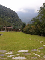
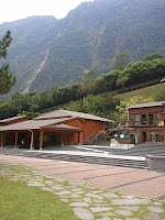
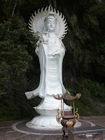
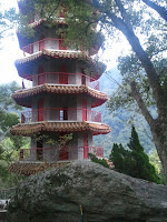
There area a couple of sights to see at Tianxiang but the ones that you shouldn't miss are all on one hill where you find the Buddhist Temple, a pagoda which seems to be the highest point in the area, and some giant Buddha statues. You can climb up the pagoda. There is no warning by the entrance saying otherwise. I just didn't because the place is already around 500 meters above ground and imagining myself falling from that height all the way down to the gorge is painful enough. That's just my imagination at work, what more real life?
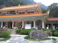
Anyway, that area was the most peaceful place. No wonder they build those temples on hills, it'd be really easy for you to find tranquility there. I wanted to stay longer but because the bus would leave in half an hour, I had to cut it short. I simply love that place at the temple area.

And so my Hualien trip ends here. Paragliding next time, maybe. I love nature trips but I am missing the city already. I don't know if I should head to Taitung or Kaoshiung next or just go back to Taipei. I am bored. I need a large modern mall.


_poster.jpg)


0 creature(s) gave a damn:
Post a Comment